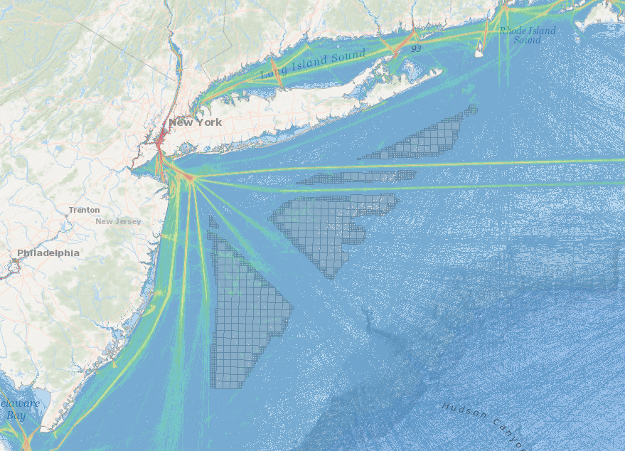
A new interactive map showing potential offshore wind energy areas in the New York Bight is now online to help mariners assess the potential impacts on their livelihoods, as federal officials gather information and comments this month.
The MARCO Marine Planner system allows users to choose from drop-down lists, and overlay charts showing all kinds of existing maritime uses, from shipping and commercial fishing to recreation.
BOEM held a series of public meetings in the region to review what it knows so far about existing uses and environmental factors, and solicit more information from wind companies, state agencies. The agency recently published a “call for information and nominations” from companies interested in commercial wind energy leases, and the information collected will influence decisions about offering new leases. These will go beyond 13 leases the agency has already granted to Atlantic developers.
BOEM has outlined four blocks, in part corresponding to potential areas identified by New York State energy planners. Laid out from the waters south of Long Island to east of Atlantic City, the tracts are labeled Fairways North, Fairways South, Hudson North, and Hudson South. In all there are 222 whole blocks of the Outer Continental Shelf, and 172 partial blocks, for a total area around 2,047 square nautical miles.
Some fraction of that could go to leasing, but New York’s ambitious target of 2.4 gigawatts of offshore power by the 2030s could be met with 15% to 20% of that area, said James Bennett, manager of the renewable energy program at BOEM.
The agency is accepting area nominations and public comments until May 29, 2018. At public meetings BOEM and state officials said more time may be needed, and New Jersey Gov. Phil Murphy formally requested a 180-day extension, specifically to address concerns of his state’s $2.5 billion annual commercial and recreational fishing industries.
Instructions for submitting comments and other information can be found at https://www.boem.gov/NY-Bight/.


