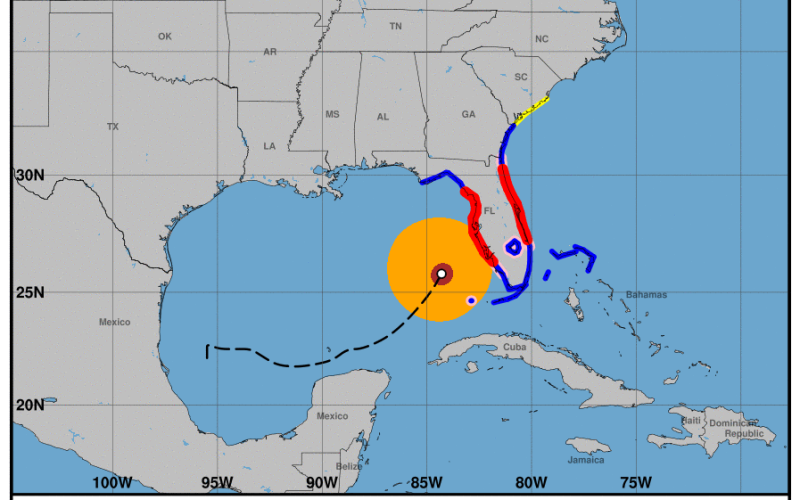
The most powerful hurricane to hit Florida’s Tampa Bay since 1921 is steamed into the state’s west coast Wednesday evening, making landfall near Siesta Key and Sarasota around 8:30 p.m. With a projected path across the Florida peninsula, hurricane Milton was forecast to dump prodigious rain totals up to 18” and even raise storm surges at Jacksonville and the St. Johns River as it exits into the Atlantic.
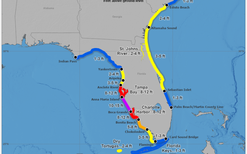
Milton approached as a category 4 hurricane with maximum sustained winds of 145 mph, moving northeast at about 17 mph. National Hurricane Center forecasters predicted a storm surge of 10’ to 15’ between Anna Maria Island and Boca Grande, and 8’ to 12’ in Tampa Bay.
Thunderstorm cells capable of tornados raked across southern Florida and the state’s Atlantic coast. Milton weakened to category 2 at landfall with winds of 120 mph but was still anticipated to move off the east coast of Florida overnight into Thursday still as a category 1 hurricane.
Tropical storm warnings were in effect from the Florida Keys and Bahamas to Georgia and South Carolina. Even after it exits Florida the hurricane is expected to push surges of 3’ to 5’ along the Atlantic coast from Sebastian Inlet, Fla., to Edisto Beach, S.C.
Florida Gov. Ron DeSantis said 9,000 National Guard troops from Florida and other states were deployed, and over 50,000 utility workers from all over the U.S. are mobilizing to restore power after the storm.
Pinellas and Sarasota counties were in line to bear the brunt of Milton’s highest storm surges. But hurricane center forecasters cautioned that last wobbles in the storm’s track of 20 to 30 miles would influence where the highest water levels go.
“You don’t have much time left,” Sarasota County Emergency Manager Sandra Tapfumaneyi warned Wednesday in a 9:30 a.m. video. She urged residents to evacuate from designated flood danger zones – and stressed that people in mobile homes and boats are in extreme danger.
“The force of 16 feet (surge) on the coastline is going to do incredible damage,” said Tapfumaneyi. She said the surge will penetrate up local streams like the Myakka River – also a scene of intense flooding during hurricane Ian in 2022 – and could reach inland to cross I-75.
“The water’s not just going to stop,” she said. “It’s going to come farther inland.”
In its long-term impact hurricane Milton may rival hurricane Andrew in 1992, which ripped through Miami-Dade County as one of only four category 5 hurricanes to make landfall in the continental U.S. In terms of damages Andrews was the costliest until hurricane Katrina hit New Orleans in 2005.
Officials at the Coast Guard 7th District headquarters in Miami said an array of aircraft, cutters and crews were pre-positioned by Wednesday for search and rescue missions and hurricane recovery including seaport reopenings and marine pollution response.
The Coast Guard forces include 27 aircraft (17 on immediate standby and 10 Coast Guard Auxiliary aircraft); 30 cutters, including 10 underway and 20 at heavy weather moorings; three floodwater response teams with 16 crews and 19 boats at Camp Blanding Joint Training Center near Starke, Fla.; and a trailered mobile incident command suite and communication trailer with 16 personnel, portable antenna and satellite systems for restoration of the Coast Guard’s Rescue 21 communication towers network.
An area command post is at Coast Guard Air Station Miami, with incident command teams at Key West, St. Petersburg, Miami, Jacksonville, Charleston, S.C., and Marine Safety Units at Canaveral and Savannah, Ga.