Geospatial firm Woolpert, Dayton, Ohio, and unmanned surface vehicle (USV) specialists Chance Maritime, Lafayette, La., have teamed up to deploy autonomous technology in a hydrographic survey of Florida’s seafloor. The partnership supports the Florida Seafloor Mapping Initiative (FSMI) and other coastal resilience projects aimed at mitigating hurricane and flood risks.
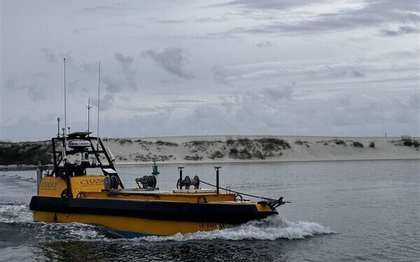
At the heart of the operation is Chance Maritime’s Mission Capable 29 (MC29), a 29’ USV capable of running continuously for more than 20 days. The MC29 is equipped with advanced sensors and real-time remote monitoring capabilities.
“What sets the MC29 apart is its ability to carry and operate our highly sensitive survey equipment while maintaining exceptional endurance,” said Dave Neff, vice president and maritime market director at Woolpert. “This vessel can run 24/7, handling rough weather up to 100 kilometers offshore. That means we get the highest-quality data in the least amount of time.”
To maximize efficiency, Woolpert coordinated a team across multiple time zones, working in staggered shifts to monitor data collection around the clock via Microsoft Teams. Chance Maritime personnel stationed in Florida maintained 24-hour oversight of the vessel.
“Even though the MC29 operates autonomously, our cross-disciplinary team was on constant watch from shore,” said Michael Scherer, chief technology officer at Chance Maritime. “If another vessel hails us, we can respond remotely. By eliminating the need for crew changes and weather-related downtime, we’ve significantly increased survey efficiency.”
Woolpert noted the MC29’s compact design allows for rapid deployment by road, making it an asset for post-storm response and other time-sensitive maritime operations. “This vessel combines the logistics of a small survey boat with the endurance and data production of a much larger vessel,” said Chance Maritime CEO Stuart Chance.
Neff emphasized the broader impact of this collaboration: “There’s a growing need for coastal mapping, dredge spoil surveys, and navigation safety initiatives. By merging our resources with Chance Maritime’s autonomous capabilities, we’ve set a new standard for efficiency in hydrographic surveying. We’re excited to continue leveraging this partnership to advance maritime operations and deliver the highest-quality geospatial data.”
.png.small.400x400.png)